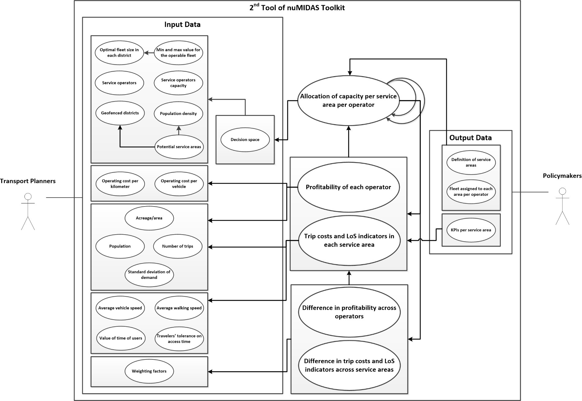
Figure 1. Intermediate UML representation of UC2
Nowadays, the mobility ecosystem has drastically changed its shape through the rise of new stakeholders and services, including the gradual penetration of connected and automated vehicle technologies, and mobility schemes relying on the principles of sharing economy. Although there exists already much research upon which many tools have been developed for supporting mobility planners and policy makers, there are still needs, which are differentiated in many thematic categories (e.g., transport planning and dynamic traffic monitoring), that require further research and development of additional tools to meet the current needs of the cities. Our nuMIDAS Deliverable 2.2. focuses on the needs of the involved cities and on the methodologies and requirements on which the development and the use of the corresponding tools will be based, in order to produce a consolidated UML (Unified Modelling Language) model for the nuMIDAS toolkit as outcome.
Building on the inputs of nuMIDAS Deliverable 3.1, pilot cities (Milan, Barcelona, Leuven, and Thessaloniki) were requested to provide feedback regarding mobility-related problems that they are dealing with by responding to a questionnaire, while the outputs of Deliverable 2.1 concerning the state of the art and business modelling analysis were used as input to the use cases scoping.

Figure 2. Adopted approach for nuMIDAS use case scoping
To successfully support transportation planners, researchers, and policy makers, emphasis has been given on the harmonisation of the development of the upcoming tools. With this objective, a series of parameters have been defined: (a) extensibility, (b) interoperability, (c) minimisation of development and operational costs, (d) reliability, and (e) usefulness and user-friendliness of the toolkit. Deliverable 2.2 presents a high-level description of the use cases, along with descriptions of problems which need to be addressed in the specific city(ies) and next the technical approach to be adopted. In addition, this deliverable presents UML mock-ups giving the visual representation of each use case approach and capture the entire process of a tool in combination with the interrelations with the involved actors. In order to make the scope of each use case more understandable and tangible, they set the boundaries of the tool, the steps to be followed each time and the requirements needed to move forward. This deliverable is deemed critical for the development of the upcoming tools, and it can be proved very useful material to guide the continuity and consistency of the nuMIDAS project.
More precisely, the deliverable focuses on the following six use cases:
UC1. Pre-planning of shared mobility services. UC1 focuses on the optimal fleet size of shared mobility services (e.g., shared bikes, e-scooters) considering different parameters and constraints such as socioeconomic parameters, mobility, financial, and service provision-related. The urgent need is the designing of a tool which will be capable of providing solution to an optimization problem to minimise the generalised cost of trips as well as the cost of the system (including operating costs).
UC2. Operative areas analysis. UC2 targets at the allocation of existing shared mobility services’ supply (i.e. operable fleet) to specific sub-areas of a metropolitan area with the aim of minimising economic losses of service providers and ensuring an acceptable level of service for citizens, in line with the principles of equitable transport systems (See Figure 1).
UC3. Air quality and vehicle emissions analysis based on multi-source data. UC3 supports the linkage and correlation of multi-source data including traffic-related, emissions-related, and weather-related data. The ultimate purpose of this linkage/correlation is to assess the impact of traffic on air-quality, forecast air quality in a short- to medium-term basis (e.g. 10 days), and/or simulate scenarios for the development and enforcement of air quality-related policies and policy instruments.
UC 4. Planning for parking. UC4 focuses on the assessment of traffic-related impacts of reducing on-street parking space within inner cities, thus supporting the formulation and enforcement of relevant policies and policy instruments, including excess searching time of affected drivers and the pressure relocated to areas adjacent to the affected one.
UC 5. Inflows and outflows in a metropolitan area. UC5 revolves around the estimation of inflows and outflows between the districts of a metropolitan area based on data generated by point-to-point detection systems (i.e. Automated Number Plate Recognition systems) as well as of census data (i.e. vehicle registration). The ultimate purpose is to support the refinement and proper enforcement of environmental policies and policy instruments (e.g., low-emission zones).
UC 6. Assessment of traffic management scenarios. UC6 involves the assessment of traffic management scenarios. The certain tool supports the assessment of C-ITS enabled traffic management scenarios based on simulation-based tools and data analytics, making use of multi-source data including data from connected vehicles fused with data from conventional counting systems.


